Unlock Hidden Details with 3D Scanning Services Philippines
March 10, 2025
What Can 3D Modeling Services Do for Your Business?
June 26, 2025What if you could explore a landscape, building, or entire city without ever setting foot on the ground? 3D aerial scanning makes this possible. By capturing detailed images and data from above, this technology creates accurate three-dimensional models of any area. It’s a practical tool used in construction, environmental studies, disaster response, and more. With 3D aerial scanning, you gain a clear, comprehensive view of spaces that are often hard to access or understand from the ground. Let’s take a closer look at how it works, where it’s used, and why it’s transforming the way we see the world.
How 3D Aerial Scanning Works
3D aerial scanning is a process that combines advanced technology and precise data collection. It starts with capturing images from the air and ends with creating detailed 3D models. Here’s how it all comes together.
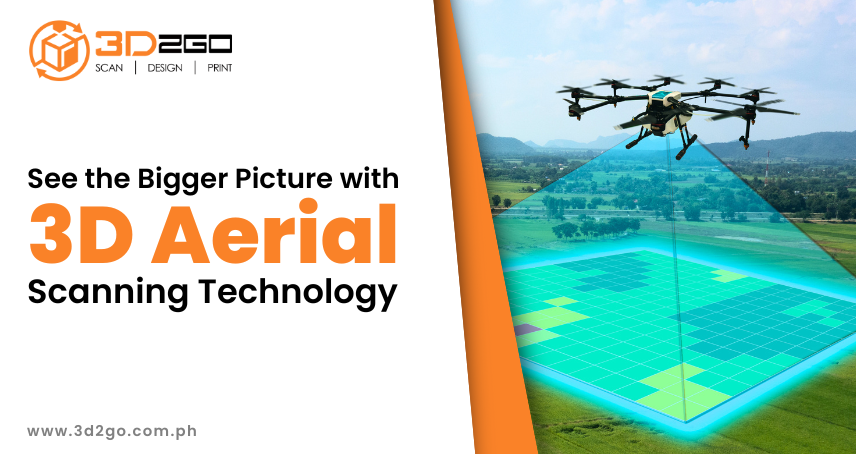
3D aerial scanning uses drones or aircraft to capture detailed images and data from above. These images are then processed to create accurate 3D models. It’s like taking a 3D snapshot of the world from the sky.
The Role of Drones in Aerial Scanning
Drones are often used because they are flexible and can reach areas that are hard to access. They carry cameras and sensors to collect data, making them ideal for detailed scans.
The drone flies over an area, taking multiple photos from different angles. These photos are combined using software to create a 3D model, ensuring every detail is captured.
Specialized software like photogrammetry programs processes the images. These tools turn 2D photos into 3D representations, providing a clear and accurate view of the area.
Applications of 3D Aerial Scanning
3D aerial scanning isn’t just a cool technology—it’s incredibly useful in many fields. From construction to environmental studies, it’s making a big impact. Let’s look at some of the key areas where it’s being used.
1. Construction and Architecture
In construction, 3D aerial scanning helps plan projects and monitor progress. It provides accurate measurements and visualizations of sites, reducing errors and improving efficiency.
2. Environmental Monitoring
This technology is used to study forests, coastlines, and wildlife habitats. It helps track changes over time and supports conservation efforts by providing detailed data.
3. Disaster Management
After natural disasters, 3D aerial scanning assesses damage quickly. It helps plan recovery efforts and identify unsafe areas, speeding up response times.
4. Urban Planning
Cities use 3D models to plan infrastructure projects. It helps visualize how new buildings or roads will fit into existing spaces, ensuring better design and functionality.
Benefits of Using 3D Aerial Scanning
Why is 3D aerial scanning becoming so popular? The answer lies in the many advantages it offers. From saving time to improving safety, it’s a game-changer for many industries.
-
Saves Time and Resources
Traditional surveying methods can take weeks. 3D aerial scanning completes the same task in days or even hours, making projects faster and more cost-effective.
-
Improves Accuracy
The technology captures precise details. This reduces errors in measurements and planning, ensuring better results for any project.
-
Enhances Safety
Drones can scan dangerous or hard-to-reach areas without putting people at risk. This is especially useful in construction or disaster zones, keeping workers safe.
-
Provides Better Visualization
3D models give a clear, detailed view of an area. This helps teams make informed decisions and communicate ideas effectively, improving overall project outcomes.
Industries Transforming with 3D Aerial Scanning
3D aerial scanning is changing the way industries collect and analyze spatial data. By providing detailed and accurate 3D models, this technology improves decision-making, enhances efficiency, and reduces risks. Here’s how it’s making an impact across different fields.
1. Real Estate and Property Development
Real estate developers and architects use 3D aerial scanning to create detailed property models, analyze land topography, and streamline construction planning. This technology allows for virtual site visits, helping buyers and investors make informed decisions without physically being there. It also aids in urban planning by providing precise visualizations of how new buildings will fit into existing landscapes.
2. Mining and Resource Exploration
The mining industry relies on accurate terrain data to locate resources and plan excavation safely. 3D aerial scanning enables companies to map mine sites quickly, assess geological features, and monitor environmental impact. By identifying risks like unstable ground, it also enhances worker safety and ensures compliance with environmental regulations.
3. Agriculture and Precision Farming
Farmers are turning to 3D aerial scanning for better crop management and resource allocation. By capturing high-resolution images, this technology helps monitor soil health, detect plant diseases, and optimize irrigation strategies. It enables precision farming, reducing waste while maximizing yield, ultimately leading to more sustainable agricultural practices.
Comparing 3D Aerial Scanning with Traditional Methods
While traditional surveying and imaging methods have been used for years, 3D aerial scanning offers significant advantages in terms of speed, accuracy, and accessibility. Let’s explore how it compares to other techniques.
Differences Between 3D Scanning and Satellite Imaging
Satellite imaging provides broad geographic coverage, but its resolution is often limited, and cloud cover can interfere with data collection. In contrast, 3D aerial scanning, especially using drones, offers much finer detail and the ability to capture data at specific times and locations. This makes it ideal for applications requiring high precision, such as construction site monitoring and environmental assessments.
How It Compares to Ground-Based Surveys
Traditional ground surveys involve manual measurements, which can be slow, labor-intensive, and prone to human error. 3D aerial scanning automates data collection, covering large areas quickly and with greater accuracy. This reduces the need for field personnel to navigate difficult or hazardous terrain, improving both efficiency and safety.
When to Use 3D Aerial Scanning vs. Manual Inspections
Manual inspections are still valuable for close-up assessments, such as checking structural integrity or inspecting machinery. However, 3D aerial scanning is ideal for large-scale projects where rapid data collection and precision are needed. It is particularly useful in inaccessible locations, such as disaster-stricken areas, dense forests, or high-rise construction sites.
Challenges and Limitations of 3D Aerial Scanning
While 3D aerial scanning has many benefits, it’s not without its challenges. Understanding these limitations helps in planning and using the technology effectively.
Weather Conditions
Bad weather can affect the quality of data. Rain, wind, or fog may limit when scanning can happen, causing delays in projects.
Cost of Equipment
High-quality drones and software can be expensive. This might be a barrier for smaller projects or organizations with limited budgets.
Data Processing Time
Creating 3D models requires powerful computers and time. Large projects can take days or weeks to process, which may slow down progress.
Legal Restrictions
Flying drones is regulated in many areas. Permits and permissions are often needed, which can delay projects and add extra steps to the process.
Transform Your Vision with 3D Aerial Scanning
At 3D2GO Philippines, we provide end-to-end 3D solutions, including high-precision 3D aerial scanning and mapping. Whether you need accurate terrain models for construction, urban planning, mining, or agriculture, our state-of-the-art drone technology ensures fast, reliable, and detailed results.
With our expertise in 3D scanning, design, and printing, we help businesses turn data into actionable insights. Reduce costs, improve efficiency, and gain a new perspective on your projects.
Get started today! Contact 3D2GO Philippines and bring your ideas to life with the power of 3D aerial scanning.


