What is Lidar and Why Is It So Important?
September 17, 2024
The Future of Statue Restoration: Combining Traditional Techniques with 3D Printing
October 4, 2024Why is Lidar technology crucial for design, construction, and mapping?
In recent years, Lidar technology has become one of the most transformative tools across multiple industries, including design, construction, and mapping. Lidar, which stands for “Light Detection and Ranging,” uses laser pulses to create high-resolution 3D maps and models of landscapes, structures, and objects. It measures the distance between the scanner and an object by calculating the time it takes for the light to return. This method allows for precise measurements and detailed images of the environment.
Lidar technology has found crucial applications in various fields, from urban planning and construction to environmental conservation. Here in the Philippines, Lidar technology has played a key role in projects ranging from infrastructure development to disaster management. The ability of Lidar to provide accurate, real-time data makes it invaluable for creating topographical maps and site plans, essential tools for designers and engineers.
One notable example of Lidar technology’s impact in the Philippines is its use in disaster risk reduction and management. In a country frequently hit by typhoons, floods, and other natural calamities, Lidar technology has been instrumental in creating accurate flood hazard maps. These maps help local governments and communities prepare for disasters by identifying flood-prone areas, which in turn informs the planning and construction of flood control systems. The detailed data provided by Lidar has not only improved safety measures but also contributed to smarter urban planning in disaster-prone regions.
How Lidar Works
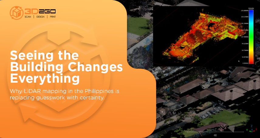
At its core, Lidar technology relies on laser pulses, which are emitted from a scanner and reflect off surfaces. By calculating the time it takes for the light to return to the sensor, the system can measure the exact distance to an object. When these measurements are taken across a large area, they can be combined to create a highly detailed 3D map of the environment.
The real power of Lidar lies in its precision. It can detect even small changes in elevation or surface features, which makes it ideal for creating accurate maps and models. Unlike traditional surveying methods, which can be slow and labor-intensive, Lidar can quickly scan large areas, reducing both time and cost. This is particularly important in industries like construction, where accurate and timely information can make or break a project.
In the Philippines, Lidar technology was used in several government-led initiatives aimed at improving infrastructure and environmental monitoring. For instance, the University of the Philippines’ DREAM (Disaster Risk Exposure Assessment for Mitigation) Program employed Lidar to map out the country’s river systems and flood-prone areas. This project helped local governments make informed decisions about flood control and disaster management, particularly in areas like Marikina, which is frequently affected by heavy rainfall and typhoons.
Applications of Lidar in Design and Construction
One of the key reasons Lidar technology is so important is its application in the design and construction industries. When it comes to large-scale construction projects, such as bridges, highways, and skyscrapers, accurate data is crucial. Lidar technology provides the level of detail needed to create precise site plans and topographical maps, which are essential during the planning and design stages of any project.
For example, in the construction of new roads or highways, Lidar technology is used to scan the landscape and generate 3D models of the terrain. This allows engineers to design roads that take into account natural features like hills, valleys, and water bodies. In the Philippines, the Department of Public Works and Highways (DPWH) has used Lidar technology in various infrastructure projects to ensure that roads, bridges, and other structures are built with precise understanding of the topography.
Lidar also helps in identifying potential construction challenges before they arise. For instance, during the initial phases of a building project, Lidar can scan the site and reveal underground structures, such as old foundations or pipes, that may not be visible on the surface. This early detection allows engineers to plan around these obstacles, reducing the risk of delays and unexpected costs during construction.
Lidar in Mapping and Urban Planning
Beyond construction, Lidar technology is also a game-changer in mapping and urban planning. In cities, Lidar can be used to create 3D models of entire neighborhoods, providing urban planners with the information they need to design more efficient and sustainable spaces. These models allow for better planning of infrastructure such as roads, public transportation, and utilities.
In the Philippines, urban centers like Metro Manila have benefited from Lidar mapping for improved urban development. The Metro Manila Development Authority (MMDA) has incorporated Lidar data into its urban planning efforts, using it to map out densely populated areas, identify potential flood zones, and plan for future developments. This technology helps to ensure that new structures are built with an understanding of their environmental impact and how they will fit into the existing landscape.
One of the most significant uses of Lidar in mapping is in environmental conservation and disaster preparedness. The country’s numerous mountains, rivers, and coastal areas make it susceptible to natural disasters, particularly typhoons and flooding. Lidar technology has been used extensively to map out these areas and assess risks. The resulting data is then used to inform government policies and disaster response strategies.
For example, after Typhoon Yolanda (Haiyan), one of the most powerful typhoons ever recorded, Lidar technology was used to map the damage and assess the areas most in need of rebuilding. This data was crucial for directing resources to the hardest-hit communities and ensuring that new structures were built in safer locations.
The Future of Lidar in the Philippines
As Lidar technology continues to evolve, its potential applications in the Philippines are vast. From smarter urban planning to more resilient infrastructure, Lidar will play a key role in shaping the country’s future. Moreover, with ongoing challenges posed by climate change, Lidar’s ability to monitor environmental changes and assess risks will be crucial in helping communities adapt to new realities.
In summary, Lidar technology has already proven its worth in the Philippines through its applications in disaster management, construction, and urban planning. Its accuracy, speed, and versatility make it a powerful tool for creating safer, more sustainable cities and infrastructure. As the technology becomes more accessible and advanced, we can expect Lidar to continue making a positive impact across multiple sectors in the country.


