3D Printed Musical Instruments: Transforming the Musical World One Tune at a Time
May 18, 2022
Creating 3D Printed Christmas Ideas With A Snapmaker Original
May 18, 2022BAM Infra laser scanning services
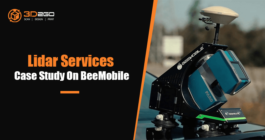
BAM Infra recorded 3D road models using a Faro terrestrial laser scanner with the innovative BeeMobile mobile mapping system.
An essential part of the infrastructural business process within BAM is the geodetic field.
Mobile Mapping of BAM Infra
Since the introduction of Mobile Mapping (MM) systems, BAM Infra has been looking at the quality, possibilities, and feasibility of an MM system. Until the end of 2019, various MM products were considered and tested.
However, high-end solutions from leading brands turned out to be impracticable in terms of investment level or left a lower quality impression.
At the end of 2019, the company STORMBEE from Ghent (Belgium) launched an IPO of their innovative BEEMOBILE system. In 2020, this system was tested and evaluated on a number of BAM Infra projects.
Process of a road aerial survey for a geodetic field
In 2020, BAM Infra recorded 3D road models via geodetic surveys at various locations across The Netherlands.
Geodetic surveys cover large areas of the Earth’s surface. It is a science that locates and relates the position of objects on the earth relative to each other, while taking into account the size, shape and gravity of the earth.
This type of survey is suited for large areas and long lines and is used to find the precise location of basic points needed for establishing control for other surveys.
Horizontal and vertical networks that span the country form the primary spatial reference system used in mapping, boundary demarcation, and other geomatics applications.
Practical applications of geodesy include monitoring earth movement and determining the precise location of points on the surface of the earth, for use in satellite tracking and global navigation.
Various specialist use this knowledge to serve both internal and external customers as much as possible.
Traditional equipment such as tachymeters, GNSS receivers, static scanners, and drones have been used on a regular basis for geodetic surveys five years.
However, this equipment lacked an important system, namely a mobile scanning system. To make up for the mobile scanning system, BAM Infra combined two surveys to cover a wider range.
Below is the scanning process using aerial and geodetic surveys:
- After a preliminary survey in which any obstacles and impediments were inventoried, the first step was to place the base station.
The base station used by BAM was a Leica GS16. This was positioned roughly halfway along the route. After mounting the BEEMOBILE on the vehicle, the mobile survey was started.
Before the start of the survey, data logging was started on the base station. It logged an interval of one second during the entire survey.
- After mobile data collection, a number of control points were collected.
These were preferably high-contrast objects such as painted surfaces and signs that were clearly recognizable in the point cloud. If applicable, Ground Control Points (GCPs) were also applied to related drone measurements.
- The collected data were processed successively with:
- POSPac post-processing software
- BEEFLEX point cloud processing
- CloudCompare
- Autodesk Recap
There are many possibilities to provide objects with dimensions. It may include but is not limited to the distance of trees from the road, the distance between trees, and the crest height.
- After post-processing and verification, high-quality data was available for the design process. The point cloud was read into Autodesk Civil 3D via Autodesk Recap.
The two main products designed with the collected data were:
- new road model/overlap model
- design of road markings and lines
- A Rehab Corridor road model was built within Autodesk Civil 3D. This made it possible to quickly generate length profiles and cross-sections and to run camber profiles.
- The next step was to make an export of the road model design software.
During this design phase, an accurate new road model could be constructed using various design parameters such as comfort slope and camber and other constructive measures that fully met the client’s requirements.
- After road model modeling, the design process was completed in Autodesk Civil 3D.
- The final result was a design/outline drawing including asphalt or milling figures, cross-sections, length profiles, and quantities.
The lines generated from the scan data were also used to create road marking plans. The road marking plan forms the basis for the control line plan with which the asphalt spreading machines are controlled.
We don’t limit our services with lidar uses
With the use of the BEEMOBILE MM system, BAM Infra had the opportunity to quickly and accurately acquire 3D road models.
The system is a no-nonsense measuring system without unnecessary and expensive extra features. The combination of a highly accurate scanner of Faro with a high-quality IMU makes it possible to obtain high-quality 3D point clouds that are of considerable added value in the work process of BAM Infra.
3D2GO has the capability to achieve what BAM Infra has done as well. Maybe even exceed as our 3D services are not limited to scanning and modeling.
Find out more of our end-to-end 3D services by emailing us at management@my3d.com.ph or reach us via our Facebook and Instagram pages for all details!


